
Before entering Isle Royale National Park:
Consult Park officials for current regulations. Visitor permits are required and limitations do apply. They are available at ranger stations on the island. Advance reservations are not available. Campsites are first come first served.
Consult Park officials for current regulations. Visitor permits are required and limitations do apply. They are available at ranger stations on the island. Advance reservations are not available. Campsites are first come first served.
mouse over to zoom
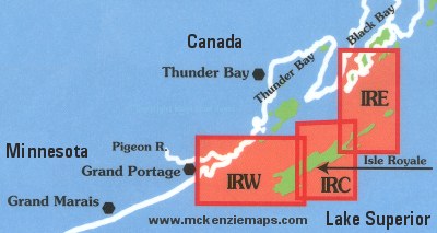
Map IRE - Isle Royale East
This map details the eastern portion of Isle Royale National Park. Covers from Gull Rocks West, to McCargoe Cove on the North and Outer Hill Island on the South. Scale is...
Map IRC - Isle Royale Central
This map details the central portion of Isle Royale National Park. Covers from Amygdaloid Island on the North, West to Lake Desor. From Rock Harbor West, to Siskiwit Bay on the...
Map IRW - Isle Royale West
This map details the western portion of Isle Royale National Park. From Lake Desor West, to Grand Portage, South to Fishermans Reef, and Rainbow Point. Scale is 1:64000.
Isle Royale Complete Map Set
This set of 3 maps includes numbers IRE, IRC and IRW which cover the entire island of Isle Royale. Scale is 1:64000.