
The maps of the North Shore/Superior National Forest offer multiple use wilderness opportunities. They show hiking, biking, ski and some snowmobile trails and many other outdoor facilities. There are many beautiful State Parks which offer varied facilities from hike-in to drive-in camping, as well as wayside conveniences. Also shown on these maps are the North Shore State Trail and the Superior Hiking Trail.
The Superior Hiking Trail lies along the North Shore highlands, a unique, rugged landscape adjacent to the North Shore of Lake Superior. It runs from near Two Harbors to North of Hovland near the Canadian Border, and offers wilderness to near wilderness conditions. You can make short day trips or extended overnight backpacking trips. There are some campsites and shelters, and no motorized use is allowed.
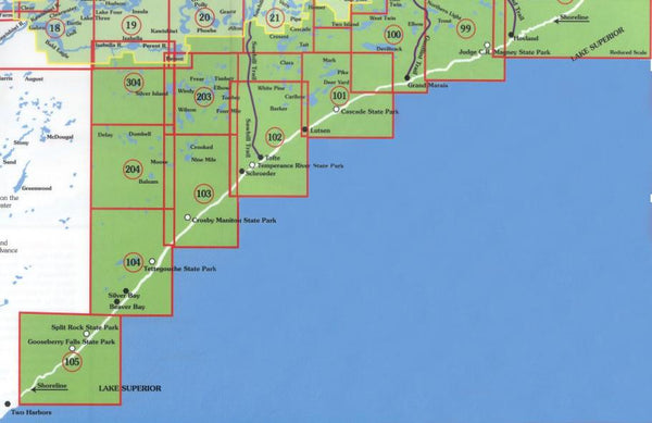
View/Download high-resolution map index
mouse over to zoom
Map 98 - Grand Portage Arrowhead Trail
This map details the Minnesota North Shore of Lake Superior. Including the International border area of Ontario and Minnesota, Grand Portage National Monument, Arrowhead Trail, Pigeon River and the towns of...
Map 99 - Tom Lake and CR Magney State Park
This map details the Minnesota North Shore of Lake Superior. Including the Judge CR Magney State Park, Tom, Trout, Northern Light Lakes, the Brule River, and the town of Colvill, Minnesota....
Map 100 - Grand Marais
This map details the Minnesota North Shore of Lake Superior. Including the first one-third of the Gunflint Trail, East and West twin Two Island, Elbow and Devil Track Lakes. Also included...
Map 101 - Cascade River State Park Bally Creek
This map details the Lake Superior North Shore of Minnesota area. Including the Cascade River State Park, the Cascade River and Bally Creek, the Caribou Trail, Mark, Pike, and Deer Yard...
Map 102 - Lutsen, Tofte, Schroeder and Temperance River State Park
This map details the Minnesota North Shore Lake Superior towns of Lutsen, Tofte and Schroeder. Including the first two thirds of the Sawbill Trail, White Pine and Barker lakes. Scale is...
Map 103 - Taconite Harbor/Little Marais and Crosby Manitou State Park
This map details the Minnesota North Shore Lake Superior area of Little Marais, Taconite Harbor, George Crosby Manitou State Park and the Finland State Forest. Scale is 1:31680.
Map 104 - Beaver Bay/Silver Bay and Tettegouche State Park
This map details the Minnesota North Shore Lake Superior area of Beaver Bay and Silver Bay, Minnesota and the Tettegouche State Park and Palisade Head. Scale is 1:31680.
Map 105 - Gooseberry and Split Rock Lighthouse State Parks
This map details the Minnesota North Shore Lake Superior area east of Two Harbors, Minnesota. Including Gooseberry and Split Rock Lighthouse State Parks. Scale is 1:31680.
Map 203 - Timber and Frear Lakes
This map details the Superior National Forest north of Lake Superior and west of the Sawbill Trail, including the Timber Frear area. Scale is 1:31680.
Map 204 - Dumbell and Balsam Lakes
This map details the Superior National Forest area north Lake Superior and west of the Sawbill Trail. Scale is 1:31680.
Map 304 - Silver Island
This map details the Superior National Forest area north of Lake Superior and west of the Sawbill Trail, including the trail head for the Pow Wow Trail, Entry point #86. Scale...
Superior Hiking Trail Complete Map Set
This set of 8 maps includes numbers 98-105, which cover the entire Superior Hiking Trail. The Superior Hiking Trail lies along the North Shore highlands, a unique, rugged landscape adjacent to...